Learning about urban planning and the anatomy of cities is a long and continuous process, and from then, very complex, where to access resources quality for the understanding of cities can mark the difference between a livable city or literally "little healthy – uncomfortable” for its inhabitants.
We can recognize that cities are growing by leaps and bounds. of giant where in most cases, the developments of tall buildings and multiple types of blocks are increasingly common. This is creating a number of problems on the health of residents and to a greater extent for those households with fewer resources.
How does the built environment affect health? … It is one of the big questions in the face of overcrowded cities where the large urban planning offices not only need engineers, architects or even mathematicians for urban planning with Big Data. Now they look like other figures like the health professionals involved in the process planning and the anatomy of the city and that provide a health map for urban settlements rather than interesting.

Diagram showing the correlation between well-being and health of a neighborhood belonging to the Conferences of Boyer.
We know that socioeconomic status is related directly with well-being and health, and that both factors are related to the neighborhoods people live together with transportation systems and their jobs. By example…
All this makes up some negative factors that affect our physical and mental health, and therefore, the power better understand cities, their infrastructures and blocks or what is called cellular urbanism is necessary to improve the future of cities. In this sense we want address two resources that we find very interesting:
Although from article 10 urban landscapes and the article on how to understand cities we begin to break down the growth characteristics of cities has given us seemed very interesting an "urban card game" where by means of 50 cards it is analyzed in a simple way the process of designing a city from the blocks.
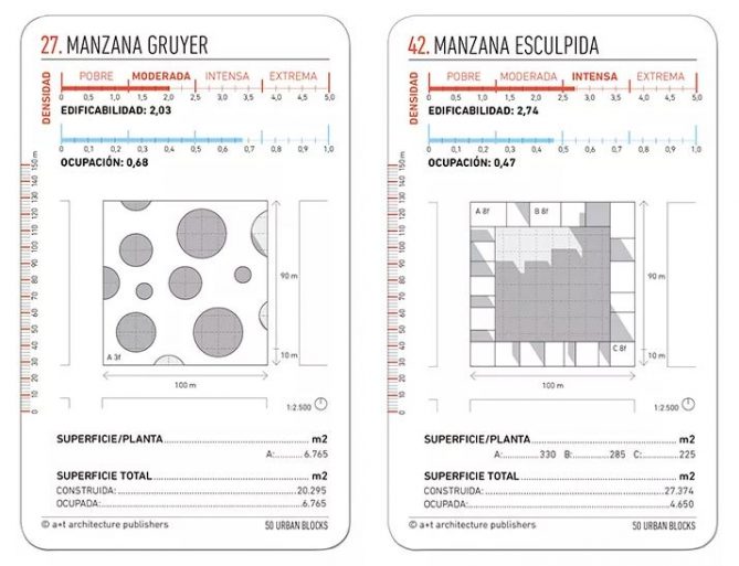

Each 13 x 8 centimeter card shows one way different organization of the different apples and blocks of a city. Where by means of an aerial view and diagram isometric together with training on the density of the form, the proportion of area, height, or coverage among others parameters the different typologies are analyzed. (It's in two languages, one side in English and the other in Spanish)

The different cards were created with the aim of use them as a tool for thought, debate, to be able to offer alternatives and inspire urban planners and arquitectos… You can access and buy the cards from HERE.
We can all recognize that different urban designs will determine a type of city, but it has rarely been analyzed the existing symbiosis between apples and vials to to illustrate its anatomy and identity of a city. A book written by the urban planner Robin Renner with the title of Anatomy and identity of the city, has classified the anatomy of the urban landscape as if it were some kind of microscope giant.
To see through the book the urban planners and the architects can begin to learn and identify potential problems existing in specific areas where networks of traffic and usage patterns to understand what type of "cells" urban have our cities or try to avoid mistakes negative infrastructure futures.
For example, thanks to this research it has been possible to know that residential blocks must be within radii between 360 and 720 meters, or that the industrial zones that They are usually close to transit routes (railways, highways, rivers and lakes) can grow too isolated and with excessive sizes becoming real problems.
It is a book that helps cities maintain a healthy balance between functionality and habitability.
We remember two articles of interest on urban planning on how design roads playing and the urban design manuals with more than 30 documents to learn.