Enter a bunch of tools that Google has access to free, there is Google Earth . Very similar to Google Maps, but with some different features, for example, view the buildings in a 3D environment from a view aerial.
The main view of the Google Earth map is with orthophotographs (A photographic presentation of a land surface). We move and "navigate" in an environment more real for the observer, as if we were a bird.
With this in mind… Can we create a catalog of our works, buildings, projects, and put them in the map? Well, directly, yes.
We can create presentations with Google Earth slideshow style to show the client our architecture projects, and, furthermore, it is totally free. You can see our example from HERE…
And it looks pretty realistic. We have created the following tutorial to present our catalog in Google Earth… Shall we start?
Content menu:
So you don't waste time, you should follow the following steps to create a good exhibition of our projects:
For Google sliders with images satellites , first consider what you want to present in the catalogue, and then we will need several photos of each project and descriptive text (recommended two to three paragraphs). See example of needs:
The image above is just an example of how to create a Google Earth route with consistency, but, the final design will depend on your needs.
In order to create the presentation and view the global mapping , although not required, it is better to enter through a Google account, so the Created project will be automatically saved to Google Drive as a copy.
Highly recommended to enter through the computer. To access to the desktop application from HERE, and you will immediately see the "Run Google Earth" button. If it is with a mobile, it will ask you install the Google Earth App for Android or Apple HERE.
Go to the panel on the left and click on "projects" as the next image….
By clicking on the "create" button we have two options:
As we have seen in the first point, a presentation is formed by several slides or sliders in the style of a Power Point presentation and that, together, create a 3D route interactive.
For each window or slide, we can opt for TABLE FORMS OF REPRESENTATION (In each of the representations, we can change its characteristics):
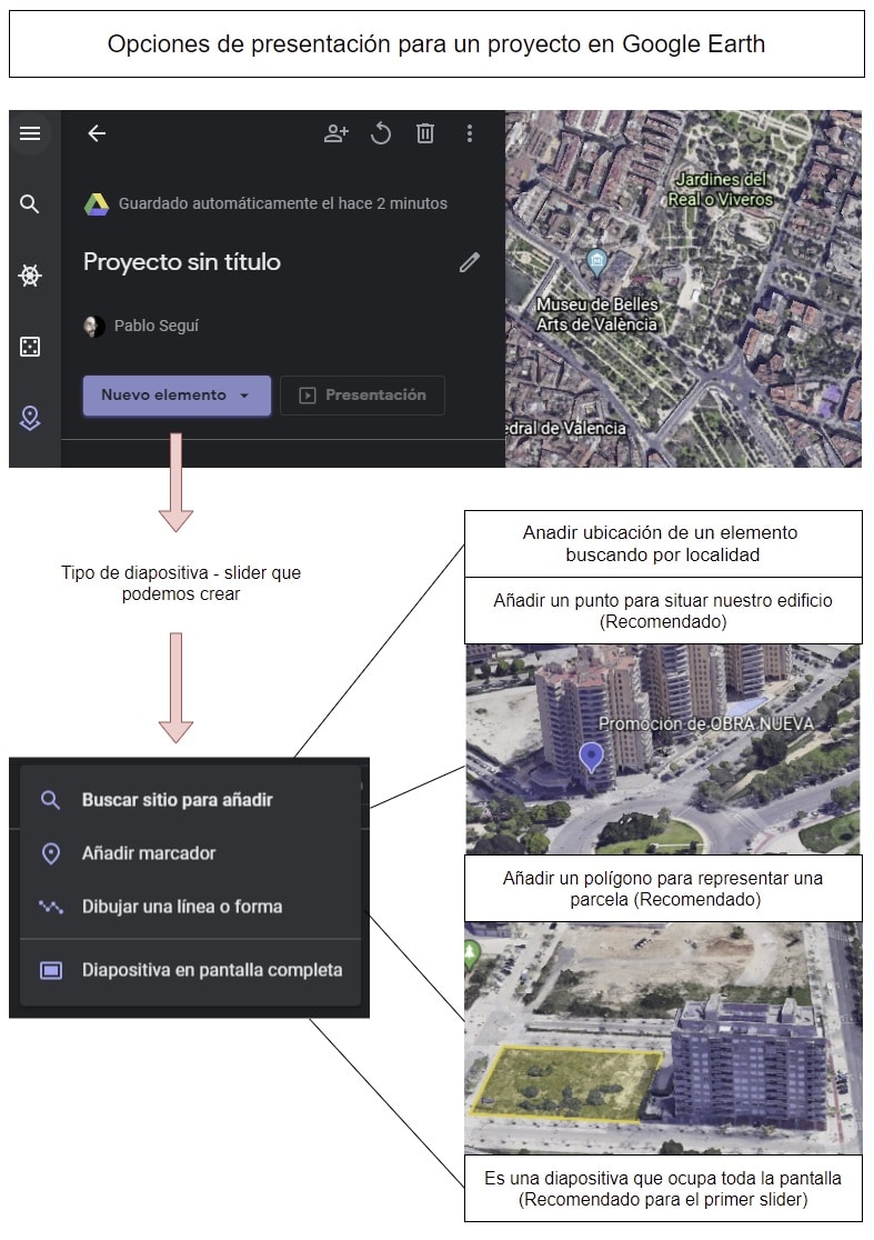
You will see that it is easy to edit a map in Google Earth . Each of the above options has its editing features, although, broadly speaking, they are very similar. And three sections stand out:
In the following image we can see the most noteworthy to create a project in Google Earth where we already added color, features, photos, description, etc:
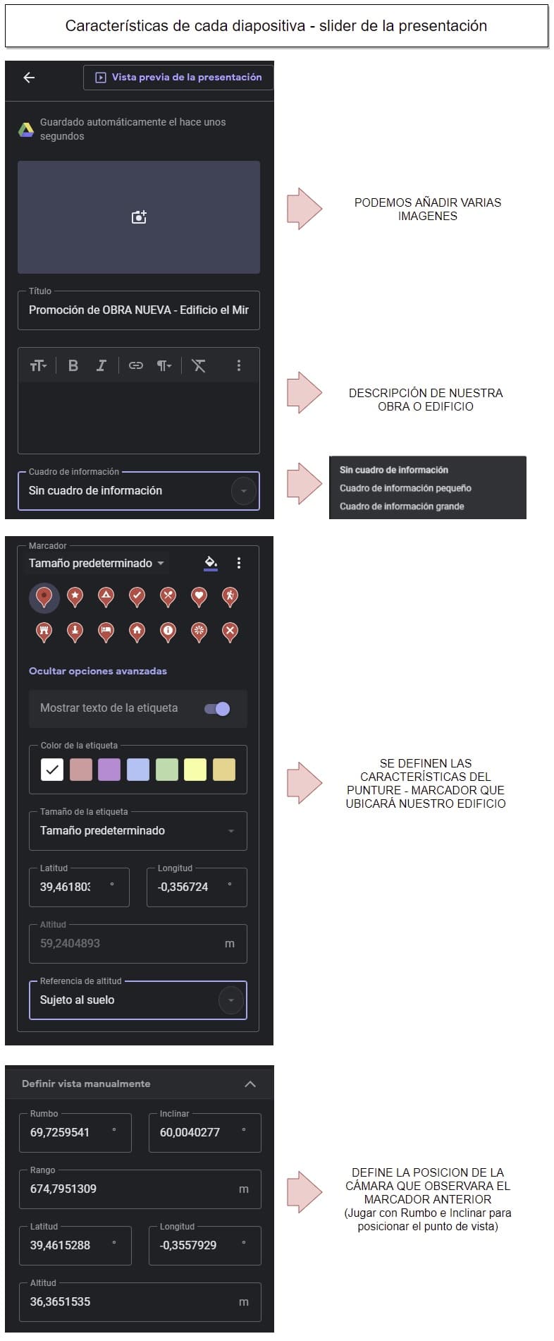
Watch out! When the images are uploaded they should weigh little and be optimized for the browser, otherwise when passing the windows may appear some in "black". As an option, from this Google tool the quality and weight of quick way. You can also see our article to improve image quality with other options.
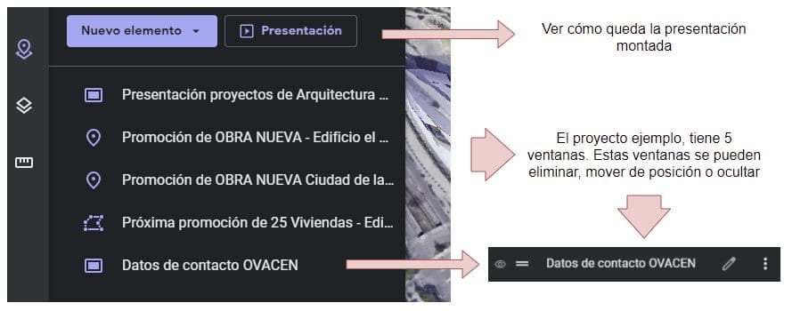
The route that we have presented at the beginning of Home Repair Care would be composed of five windows that we can move, delete, hide etc:
Remember that we also have an article on how to see street old view getting a before and after look at a place.
The easiest way to share a project Google Earth is via a link. This, it we can use to link to a button on our website, share on social media or send to customers:

As a note, I recommend that once you have the URL to share; First, open it with the browser. there, you will see that the first screen is the one that represents the summary of layers that the project has. The URL that is best for us, is the one that when clicking on "Presentation" opens the window use that URL!… So the clients will directly see the presentation without going through the layers area.
In this case, and as a summary, we have searched for a video with simple explanation of how to take a tour in Google Earth :
Although we have not discussed it, this tool has many Other options. From downloading the program itself, the Google Earth Pro , for our computer with interesting features, even Google Earth Studio that you can now create more interactive and professionals, but the latter is only for organizations educational.
Google has many interesting applications that we can use for our projects. We already showed how to make a tour of our works in 360º panoramic format with the virtual tour that is 100% free, you have to take advantage of it!
If you liked the article, rate it and share!