Although by now we all know the google maps and more, specifically, the google street view . We must recognize that it can be a tool very useful information in the field of architecture and urbanism before the transformation of the cities.
A transformation that can be grasped to see historic street view images and collect for the evolutionary understanding of the urban environment, either through maps or through images that represent a «before and after».
In this sense, in the environment of Googlemaps and Google Earth with their presentations, applications and platforms are proliferating whose intention is to open your eyes, observe and allow the exchange of knowledge of good urban design through the practice and how it affects our lives in cities.
Content menu:
It is possible that with the following image of gmaps let's understand the concept you want show this platform made by architects Brazilians:
The street view has long made us provides the documented public space, that is, the before and after a specific geolocation ! old view of a place!
That is why the collaborative proposal Urb-i was born. A growing database of learning before the urban spaces . Show a urbanism that improves dramatically and changes the focus and symbiosis existing between cars and the pedestrians, where we can see that the protagonist of the city is no longer the vehicle, it is the pedestrian.
In the project we find more than 300 Collaborations located on all continents and growing. You can access the platform from Urb-i.
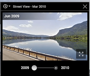
1.- To see the images on the web. you can open google map by placing the orange “little man” icon on the map or simply by clicking on the thumbnail image. To observe the old images
2.- Drag the orange "little man" from the corner lower right and drop it on the map. If there are pictures of past available, you will see the clock icon in the right corner upper left of the map. 
3.- Click on the clock icon and use the control slider that appears to go further back in time. click on the clock icon to enlarge the images history that you want to see in full screen to that period of time.
Quickly, I also leave the following video with the explanation of how to travel in time with Google Maps :
The possibilities offered by maps of google are increasing considerably according to technology advances in search of new data and more if we enter in combination with the app. we want to give a review of some characteristics that we find of interest or applications that complement.
In Gmaps , it's not just about dragging the little yellow man and let ourselves be seduced by a landscape or a city. Here the objective is to explore the corners of the world with the Contribution of the users' own images.
Wonders of architecture , routes of hiking, inside hotels or from the top of a mountain the application offers the possibility of climbing 360º panoramic images to google maps so we can all enjoy the sensations and experiences of other users.
We can find the street view app both for Android phones and for the iOS app. He access to the official portal from HERE.
Well, here we should point out, it is a montage of a video based on images in sequence, it is say, a timelapse . A scheduled route on google map and the free application on the web build a timelapse. Amazing!…
We can access the application to make a hyperlapse with street view from the website of brianfolts.com Enjoy making videos!

In short, google street-view is a powerful tool from which we can learn a lot. traveling and understanding the architecture of the world with a simple "click" is not little.
Other tools of interest to Google may be for create 360º panoramic virtual tours or the translation of texts with Google translate combined with other applications to improve texts.