Thanks to the courage of many fans of the cartography we can enjoy a map interactive that is advancing day by day in Internet implementing new features.
A new way of understanding programs survey data – open source (free) that outside the context of Google Maps, they can offer us 3D maps so that they can be used in our daily work or consultation.
From the article surveying with OpenStreetMap and Osmbuildings have been up to date with the latest developments prominent in the virtual planes in 3D that define urbanism and architecture of the city in a different way than satellite map or daily street , but at the same time it is attractive and practical.
The image above is from F4map. which provides a new new vision of the interactive maps of open source and free OpenStreetMap. Only the buildings that are vectorized but create some maps with relief of the surface of the land, elements in movement… etc. great!
We start with the list of 3D maps online …
Content menu:
As we have commented previously, they are tools that can bring a tangible benefit in our work to the time to create a map , or make a consultation or to present a work.
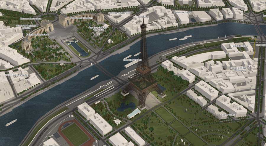
Some examples of what we can find in the interactive map of Europe would be from Paris, unlike interactive 3D google maps or the flashmaps , it seems much more real to us, with more realistic planes.
An example of an urban map:
Or from Spain , in the Plaza de España, where we can already recognize that there is an urban relief and a topography with curves on the horizontal plane in the following example of a concept map that improves the vision of virtual maps .
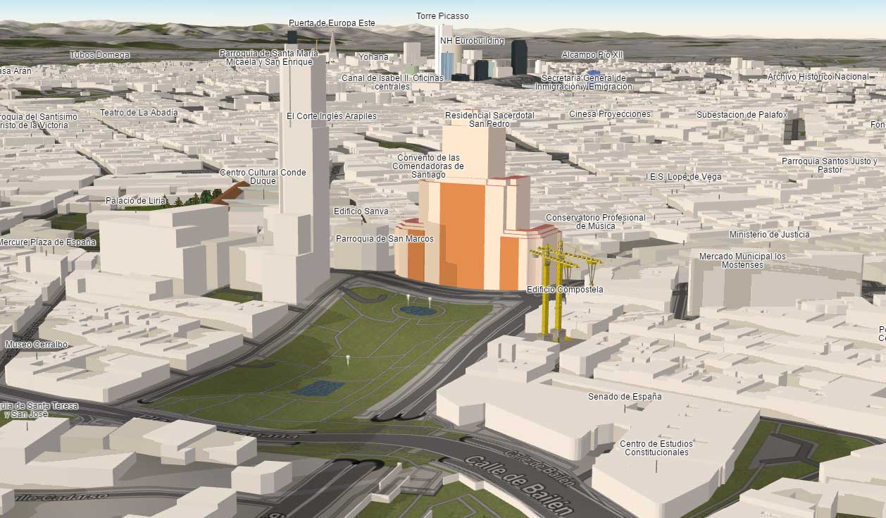
We can access from HERE to see the map of Madrid slightly more global way.
This 3D world map created by F4Map Take the data from the famous Osm Buildings, which also has that perspective in three dimensions but with fewer finishes.
The free map tool gives us different contributions and actions to be able to navigate, from the search logic and locate addresses geographically on urban space from the city, street or even the mountain, even with possibilities from activating objects, shadows of buildings according to sunlight, rain and snow or being able to navigate around a building among others.
We show in the following panel image some of the characteristics of the world atlas in its section on Graphic options .
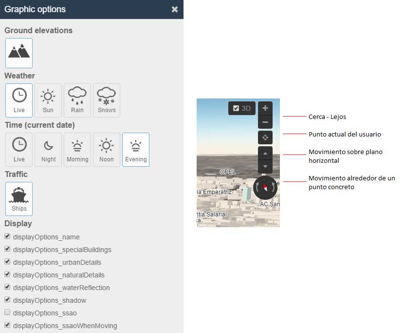
As we can see in the image, the «Ground elevations», the terrain elevations represents a new feature which provides significant improvements in visualization compared to typical satellite maps that provide flat information on the atlas of the world .
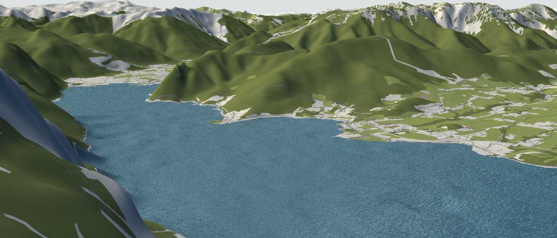
We can access from HERE to see the image of reference.
We remind you that we also have an article of interest about the best virtual reality apps in architecture… A craziness! That teaches us how far we can go with the mobile before the relief of the objects.
This interactive world map represents a utility app for any job we can although it should be noted that the contribution of information about the map by the conventional user is a little more difficult being an open source community and free based on the OpenStreetMap which is the basis of the tool that we have explained and
If you want to know more from HERE there is a guide to beginners and a new APP from HERE on the web that simplifies our work a lot to be able to add info…
Access to the interactive map we are talking about from the New York City … HERE .
Possibly the best known tool. Google Earth has amazing detail on your 3D map . The architecture of urban landscapes, especially large cities, it is quite detailed; bridges, buildings, monuments, trees, mountains, etc.
There is little we can talk about this tool supported by Google and from which, in addition, we can download a version for quite useful desktop to play with the cities in 3D .
We can access Google Earth from HERE. Just comment, I know can make exploration routes as we explained in this article on how to make a presentation with Google Earth great idea!
For lovers of the broad Apple ecosystem, it also has their geographical perspectives in three dimensions . It's Apple Maps, only for those who they use iOS, it's the only way to see it.
You have to enter from Apple Maps in iOS and you will be able to see a constantly improving platform.
One of the best features of Apple Maps is the “fly over” mode. is the way to get a virtual visit from the air of a city or place determined, as if it were a virtual tour.
This one, like the next one, is more for professionals of digital geography and to create their own maps in the pc.
The NASA World Wind that we can access from HERE. it's a kit development with a software (SDK) that has all the necessary tools so that you can create and build your own 3d map style applications personalized.
It is free, open source and cross-platform. The balloon virtual 3D" has a large collection of satellite images and incorporated land.
An old acquaintance for creating 3D maps virtual , Esri's ArcGIS Earth that you can see HERE.
Like the previous one, you need to download a application for computer or mobile. Here the ground is in 3D view, but the buildings are not.
A more complex program for 3d maps , which You need other applications to see the buildings in 3D model . on the web and Youtube has abundant information
As a complement to the information we want to provide some used and web applications for that we can work and create with more data and tools online, but from an easy perspective and that they have of a free section.
This mapping tools , in its most have access to a 3D world map interactive where our work and projects They will enhance its beauty by providing quite valuable effects.
First to highlight would be Mapme, a free tool for maps that works in a very intuitive and easy way of simple personalization, classified in different Categories: entertainment, education, health, technology, non-profit organizations, activism and art. have been in specially designed looking for an attractive aesthetic and a perfect display on any device. So it's a good option to create an interactive map comfortably.
In the customization process it is possible to summarize, organize and display the information you want by importing it through Excel documents or other data sources open.
You can create labels and layers with which to organize the content on the map. Once ready, it can be socketed – embed in any website.
All these applications have a section for the creation of free 3D maps .
